
The Annapurna circuit : 10 days in the Himalayas
- Emeline & Victor

- 5 mai 2022
- 15 min de lecture
From February 28, 2022 to March 09, 2022
Nepal, the country of the Himalayas, we had been dreaming about it for a while... So including it in our round-the-world itinerary was obvious. We had heard so much about these magnificent landscapes and this paradise for trekkers, that it was simply inconceivable that we miss it.
In this article, we tell you about our ten days experience on the Annapurna circuit, reputed to be one of the most beautiful circuits in the world!
Choosing the way
Hiking means choosing the trekking path you want to complete and it’s never easy. We spent several days doing research, we drowned in a mass of information and as a result, when we landed on Nepalese soil, we still didn't know which trekking path to choose. We hesitated between Annapurna Base Camp and Annapurna Circuit.
After listening to the arguments of the different travel agencies (which proposed Annapurna Base Camp at first), our choice fell on the Annapurna Circuit. Why this one? Because we were looking for a circuit (and not a round trip, as it is the case for Annapurna Base Camp), with some height and a great landscape diversity.
Choosing the agency
We had no intention of leaving with a travel agency, and yet, we were easily tempted. The fatigue of the organization and the issues we encountered in India are certainly not foreign to this decision. But also, it was the first time that we undertook a trek with so much height (more than 5000 meters), and not knowing the effects of the altitude on our bodies, we preferred to be careful.
After negotiating prices with three different travel agencies, we signed with Giri, the owner of Nepal Mountain Adventure. Giri proposed us the itinerary which was the most convenient for us, and was the cheapest. He was also the person who gave us the best impression during our negotiations.
The price
The Annapurna circuit was included in a larger package including a few days in the Nepalese jungle, a visit to Lumbini, birthplace of Buddha, and finally, some relaxing days in Pokhara.
Here are the details of this package:
Chitwan: 3 nights hotel with breakfast, lunch and dinner included, jungle walk, canoeing, elephant farm visit, jeep safari, traditional dance show, bird watching (+ 1 additional activity to choose).
Lumbini : 2 nights hotel with breakfast
Annapurna Circuit with guide for 13 days (nights + meals included)
Pokhara : hotel 3 nights (breakfast included)
All transportation by tourist bus and local bus included
Package price : 180 000 rupees for 2 (1 334€)
Final price obtained after negotiation: 165 000 rupees for 2 (1 200€).
Extracting the exact price of the trek from this package can be tricky, as we don't know the exact value of the days spent in the mountains. If, however, we simply try to calculate the average budget per day from the price of the package, it gives about 52 € per day for two people (26€ per person).
More precisely, was included in the price:
The accommodations during the tour,
Meals (we had the right to one menu item per meal, which was largely sufficient in term of quantity),
A guide during 13 days,
Transportation by bus and jeep,
The permit (it is necessary to have a permit to do trekking in the Himalayas. The price of this permit differs depending on the region you are going to and is absolutely mandatory since checkpoints are frequent),
Equipment rental (crampons and a pair of gloves).
We only had to pay (in addition to the package price) for cups of tea (except for the one at breakfast).
The itinerary
The picture below represents the Annapurna circuit that we did.
On two occasions, during this circuit, we had recourse to a means of transport:
- the beginning between Besisahar and Chame was done by jeep,
- the journey between Muktinath and Tatopani was done by local bus.
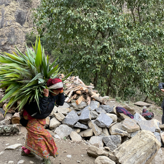
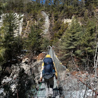
Until a few years ago, these two parts were done on foot. The country is currently trying to develop this region and has built roads on the old trekking paths. Now you have to walk for very long hours on the road, next to jeeps, buses or trucks, which honk continuously, make dust and act as if the road belongs to them.

Steps Detailed
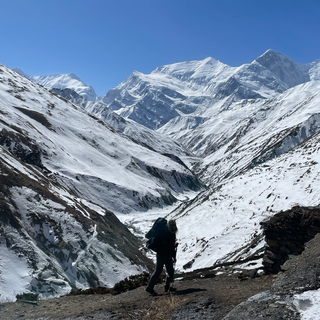
Going to Chame, starting point of the circuit
As explained above, the Annapurna circuit has changed a lot in the last few years. Whereas before, the circuit started in Besisahar, it is now possible to reach Chame directly by jeep. Some trekkers choose to reach Chame on foot, like in the old days. It is quite possible, but it is necessary to prepare for it: the road is long (between two to three days), and not very pleasant since it is necessary to walk on the side of the road, beside the jeeps which circulate.
To reach Chame from Besisahar, it is necessary to count a good day of Jeep. The landscapes on the road are magnificent and just the climb by jeep is quite an adventure! You will have a glimpse of the diversity of the landscapes on the Annapurna circuit: you will cross small villages in which the Jeep stops to make some food deliveries, you will see rice terraces, waterfalls, rivers with turquoise water below the cliff...
Abstain yourself if you have motion sickness, the roads are in a deplorable state, constant shaking during the whole trip.
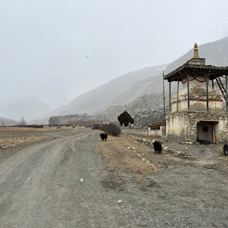
Arrived at Chame, the conditions already begin to be rough (after all, we are already at 2600 meters of altitude): there is no hot water, because the pipes are frozen and no heating in the rooms. The only source of heat is the stove of the common room. As much to say you that that puts us directly in the atmosphere!


Step 1
🗺 Chame (2670 m) -> Upper Pisang (3300 m)
↗️ 600 meters
⏳5 hours
🥾16 km
Difficulty: ⭐️
We leave our hotel at 8 am to start our ascent. The village of Chame is charming, we pass by a stupa and our guide, Tek, teaches us the meaning of the colors of the Buddhist flags: the blue for the sky, the white for the wind, the red for the fire, the green for the earth and the yellow for the water. If it is very cold at the beginning, one warms up quickly by walking.
This first stage does not present any difficulty. The view on the mountains is energizing, the sun is present all along our way. The mud is also there, result of the melting of the snow.
We have lunch in a small village which we cross, before reaching Upper Pisang, our stage for the night. It is a little more than 13 hours when we arrive there then we have the time to rest, to take advantage of the sun and especially, to admire Annapurna II which is just in front of our eyes!
Around 5 p.m., Tek takes us to visit a Buddhist temple. We spend our evening all together singing and drinking by the stove.
Again, we have neither hot water, nor wifi (which will be the case throughout the tour).


Step 2
🗺 Upper Pisang (3300) -> Manang (3540 m)
↗️ 550 meters
↘️ 400 meters
⏳8 hours
🥾20 km
Difficulty: ⭐️
The sky is beautiful when we wake up, even though it is very cold. Like the day before, we start walking at 8 am. The views of the mountains accompany us throughout our day's walk. We stop for lunch in Nagwal, where a center of rapid PCR test is installed at the edge of the road. The test is obligatory, free and completely unexpected.
When we take again our walk after the lunch, we still have 1h30 to arrive at Manang. One will make them under the snow 🥶 and in company of some yaks, which look at us passing since the mountain.
Manang is located at 3540 meters of altitude. In order for our bodies to acclimate to the altitude, we need to sleep at this altitude for at least a day. Most of the travel agencies, propose to their customers to make one day of rest in Manang. Our agency, proposed to us to make day hikes, higher in altitude in order to acclimatize even better. It is thus the objective of our third step.


Step 3
🗺 Ice Lake (4620m)
↗️ 1100 meters
↘️ 1100 meters
⏳9 hours
🥾 15 km
Difficulty: ⭐️⭐️⭐️
When the agency presented us with our schedule for this trip, it was planned for one day of acclimatization in Manang. But an acclimatization in concrete since we were proposed to go and see the frozen lake located at 4620 meters above sea level.
The ascent is difficult, especially when we arrive at the end, where the snow is thick and deep. Tek has snow up to the knees, and we, we follow him from far while he traces the way (we are the first of the season to come until here). We get tired quickly, the snow is fresh, fortunately, the sky is blue and the sun is warm. We finish this ascent on the knees, the distribution of our weight on snow allows us to advance without sinking in snow. Tek looks at us, at first, doubtful, then amused, and finally joins us.
Of course, the frozen lake being... frozen and covered with snow, we only discern the outline. But the stupa present at the top gives us a lot of courage for the descent!
When we have dinner, this evening, Tek explains us that we have to modify our step of the following day. Our route makes us pass by Tilicho Base Camp. The problem is that no hotel has reopened for the season because of the heavy snow. So we have to go directly to Manang and in doing so, we lose two days of trek. Our trek, initially planned for 13 days has suddenly been cut by two days, reducing it to a total of 11 days.


Step 4
🗺 Manang (3540 m) -> Yak Kharka (4018 m)
↗️ 550 meters
⏳4 hours 30
🥾 12 km
Difficulty: ⭐️
After yesterday, nothing can seem complicated to us now 🤣. The way to Yak Kharka seems easy, even if we walk in the mud. We arrive there for the lunch.
This afternoon, it is nap in the sun and hydration with tea. We are now at more than 4000 meters, and especially, we sleep at 4000 meters. The first symptoms of mountain sickness can be felt. The hydration is important at this stage of our journey! Tek is extremely vigilant, he regularly asks us how we feel. He warns us, it is quite normal if we do not manage to sleep properly at 4000 meters of altitude.


Step 5
🗺 Yak Kharka (4018 m) -> High Camp Thorong (4650 m)
↗️ 700 m
⏳5h30
🥾6.5 km
Difficulty: ⭐️⭐️
We hydrated well the day before, but we wake up nevertheless with a big headache. It is unpleasant, it is like having a hangover without having any alcohol 😅.
The ascent until the "high camp" (last hotel before the pass) seems interminable and difficult. We are again in the snow. The symptoms of the mountain sickness are stronger and stronger, the headache is present from morning to evening, the breathing is faster, although less efficient and the body fatigue is well installed. Sometimes we feel nauseous. At this stage, people who feel too much symptoms do not go any higher.
This afternoon, it is again hydration. Tek recommends us to rest, but not to sleep. He doubts that we can sleep properly this night so he prefers that we keep the sleep for this night. Tomorrow, we leave for the most important step of our circuit: the pass of Thorong La.


Step 6
🗺 High Camp (4650 m) -> Thorong La Pass (5416 m) -> Muktinath (3800 m)
↗️ 600 m
↘️ 1300 m
⏳8h30
🥾12 km
Difficulty: ⭐️⭐️
We wake up at 3 am, in order to leave at 4:30 am. It is important to pass the highest point (Thorong La Pass) before 10 am. After that, the wind becomes too strong and it is much more difficult and very uncomfortable to walk.
We wake up with a thundering headache, that we try to attenuate with Doliprane (what works to a certain extent).
Tek opens us the way, it is night and the possible traces of the previous hikers were erased by the snow fallen during the night. Tek does an extraordinary work, without light at the beginning, he directs us to the easiest way for us, he shares us his hot water, he rubs our hands to warm our fingers.
The wind is so strong that we have the impression that they are razor blades which pass on our face. Tek cries us to turn us back to the wind when it is too intense.
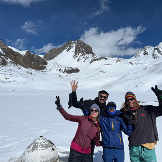
We see the first lights of the day rising. Although the landscape is incredible, we hardly notice it, too busy to put a foot in front of the other and to fight the lack of oxygen. What a joy when we discover that we have reached the pass of Thorong La! It is the culminating point of our journey, 5416 meters of altitude, nothing but that.
This good old pass of Thorong La, the highest pass of the world accessible to the Man, we are there! You put us to the test, you made us tremble, you surprised and amazed us, you taught us a lot, but we finally conquered you certainly as much as you conquered us!
And even when we are half passed out on the floor due to lack of oxygen, we can't help but smile at the spark of pride that warms our hearts. A spark that becomes a blazing fire as we begin our descent.
If the ascent was difficult, the descent is also difficult, but not because of altitude sickness... The snow is slippery, and even with our crampons we have difficulty to stay on our two legs. It seems to us interminable. The way is very narrow and we know well that a wrong step can cost us a lot...
Everything goes well, in spite of some frights 😨. We arrive at Muktinath at the beginning of afternoon. And since the beginning of our trip, we have the opportunity to take a hot shower (well, it is a paying shower, but that, we will know it too late!).


Step 7
🗺 Muktinath (3800 m) -> Tatopani (1190 m)
🚙 80 km
⏳4 hours
Today, we leave the trekking path to reach Tatopani by local bus. Once again, the state of the road is a disaster, we are shaken in all the directions. But we end up getting used to it (until the moment when our buttocks do not touch our seats anymore). The sight is beautiful.
Some people decide to walk between its two destinations. The way is the same one that the bus takes then it is necessary to like to walk in the dust and beside the traffic 😬.
We arrive at Tatopani in the middle of the afternoon. And we are more than ready to go to enjoy the hot springs which make the reputation of this city.
No walk today, but a good hot bath to relax our muscles. That makes us a crazy good (especially after all this time without hot water!).


Step 8
🗺 Tatopani (1190 m) -> Shikha (1900 m)
↗️ 994 m
↘️ 331 m
⏳3h30
🥾13 km
Difficulty: ⭐️⭐️
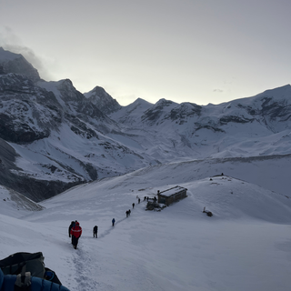
After our day of rest of yesterday (we took the bus), it is now necessary to get back in the saddle (or rather in shoes 🤪). Our goal is to reach the town of Ghorepani, to then be able to access Poon Hill, the famous 360 degree view of the Annapurna massif.
Walking directly from Tatopani to Ghorepani is a long way (very long way) that can be divided into two days. It is the option that Tek chose for us.
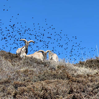
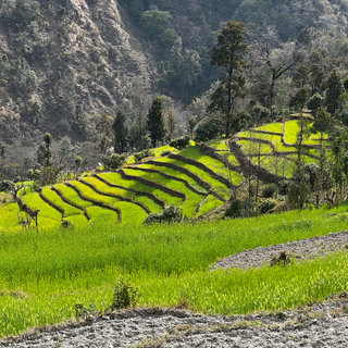
It takes us three and a half hours to reach Shikha, the middle city 😆. The path is well maintained, we are amazed by the number of stone stairs. We cross small villages, see terraced crops, monkeys, buffaloes and cows, and lots of rhododendrons, whose smell accompanies our ascent. All this with the snowy mountains of the Annapurna massif in the background of course!


Step 9
🗺 Shikha (1900 m) -> Ghorepani (2850 m)
↗️ 875 m
↘️ 57 m
⏳3h
🥾 9.3 km
Difficulty: ⭐️⭐️
At 8:30 am, we start our second day of hiking to Ghorepani. The landscapes are rather similar to what we saw yesterday. Again, it is an important number of stairs which awaits us. We are so happy when we reach the door of Ghorepani. But so discouraged when we realize that it is not because we passed the door that we really reached the village. We still have 100 meters of ascent to cover.
Again, we find ourselves the feet in the snow!
This afternoon, it is lunch in the sun and nap, before going to have dinner in the common room, near the stove.


Step 10
🗺 Ghorepani (2850) -> Poon hill (3210 m) -> Ulleri (2055 m) -> Pokhara
↗️ 360 m
↘️ 1500 m
⏳10h (including trekking and jeep time)
🥾14 km
🚙 52 km
Difficulty: ⭐️
We wake up very early, at 5 am, to go and watch the sunrise on Poon Hill. "Poon hill" means "the hill of the Poon", name given to the inhabitants of the region. We have approximately 45 minutes of ascent since our hotel to arrive there.
Up there, it is possible to drink a tea or a coffee to warm up a little. From Poon Hill, we have a 360 degrees view on (almost) the whole Annapurna massif. It is an ideal conclusion to these 10 days of trekking in the mountain (even if it seems to us hard to get up early in the morning to climb about 400 meters, without having had lunch).
We stay a little, we observe the mountains and the sun to go up gradually in the sky.
After the descent, we stop to take a breakfast before beginning the 1500 meters of descent towards the city of Ulleri.
From Ulleri, we take a jeep which takes us directly to Pokhara.
This stage marks the end of our circuit!


***
Summary
🏔 The landscapes
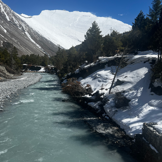
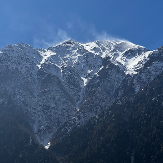
We chose the Annapurna Massif circuit for its variety of landscapes. We were not disappointed. We went from the forest to the snowy mountains, from the small mountain villages to the Buddhist monasteries and stupas, from the glaciers to the terraced cultures...
💪 The difficulty
No difficulty to report on the terrain itself which is accessible to casual hikers. Still, let's note that our journey to the frozen lake was not obvious, but this is an optional excursion.
Our main difficulties were the very cold weather (I talk about it just below 👇) and the altitude sickness 😵 (which started from 4000 meters and kept increasing until Thorong La Pass). Even if we had acclimatized and drank a lot of tea, it's still random and the symptoms can be more or less important depending on the person. We therefore recommend you to be particularly attentive to your body during this trek and not to continue if you do not feel fit enough. For more security, you can also be accompanied by a guide, who will be able to advise you on your symptoms.
⛅️ The weather
March is the opening month of the trekking season in Nepal. This doesn't mean that you can't trek outside of this season, but it is not recommended, as the weather conditions do not allow access to all places. Also, some hotels are closed outside this season.
For us who did this tour at the beginning of March, the conditions were very difficult. The cold can sometimes be extreme, especially when it is accompanied by wind. The lack of access to running water (because the water network is frozen) and the near impossibility to get hot water (to wash) has greatly complicated our experience.
We must not forget the snow, still very present at this period. Walking in the snow without getters means having wet feet, which can be very unpleasant after a while.
Moreover, snow means melting and therefore mud. We waded a lot in the mud during this tour.
Still, we were very lucky, the weather was nice most of the time ☀️.
🏠 The accommodations
When we booked our stay with a local agency, the representative kept telling us about the "tea houses" in which we would sleep, as the only accommodation available in the mountains. We did not know too much what to expect, except a summary comfort. Finally the "tea houses" in question are themselves called "hotel".
There is no heating in the rooms. The only source of heat is the stove in the common room, usually lit from 5 pm. This is also the place where everyone meets, dries their shoes, socks and other equipment...
Toilets and bathrooms can be included in the room or can be shared (this is the case of the only hotel in Thorong La High Camp). You should not count on a flush toilet, but on a bucket of water next to the toilet (you are lucky if the water is not frozen in the bucket).
Often, hotels provide two blankets in addition to the use of your own sleeping bag. And believe me, despite this, the cold is sometimes felt.
The higher you go, the more expensive the food is. It is obvious if you compare the price of a cup of tea in Kathmandu or Pokhara (between 25 and 30 rupees) and the price of a cup of tea in the heights (which can reach up to 90 rupees). The price is still acceptable for our European budgets.
The food is always fresh, that's why your dish can be long to arrive.
🧍♂️The guide
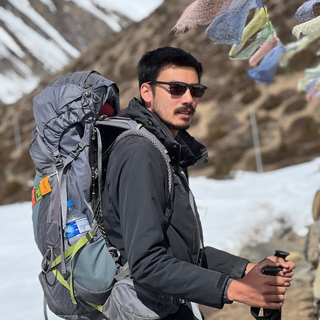
We could not have made the ascent of Thorong La without a guide. On the one hand, because at this season, the snow cover makes the path not marked and thus not locatable (especially in the night). On the other hand, because without a guide, we would not have taken the risk to continue our ascent with such symptoms of altitude sickness. The fact is that we had total confidence in Tek and that he knew perfectly how to manage the situation, while keeping a cool head. He always took care to find the best way for us, and to strengthen our courage in the hardest moments.
Having a guide also means to understand better the habits and customs of the people living in the Himalayas, but also of Nepalese in general. It means learning about the fauna and flora, it means being able to give names to the mountains that surround us and finally it means being able to get more favors in the hotels (for example, a free glass of hot water before going to bed, an extra blanket in the room, etc.).
However, not all guides are as professional as Tek's, as we have experienced on many occasions...
Link to the travel agency's website with whom we went: https://www.tripadvisor.co.uk/Attraction_Review-g293890-d23826163-Reviews-Nepal_Mountain_Adventure-Kathmandu_Kathmandu_Valley_Bagmati_Zone_Central_Region.html
Ask for Tek, he is the best guide we ever had 😉